


UPPER KEYS
In 1895, years before Flagler’s train began making tracks for the Florida Keys, politician George W. Allen gave a speech advocating the necessity of a road bridging mainland Florida and Key Largo. Even after daily railroad service had been established in the Upper Keys circa 1908, the plea continued when residents asked Monroe County officials to fund construction of a road in 1908. Farmers, especially those working the islands of the Upper Keys, needed a better way to transport their crops to packing houses established near the train’s right-of-way. The Miami Motor Club lent its voice to the argument in 1919 when representatives lobbied for the construction of a road to the Keys that would provide winter tourists with a “suburban” fishing ground. Monroe County officials allocated $300,000 for road projects in 1922. County funds were allocated for road projects in 1926, including the construction of a wooden bridge connecting Little Card Point (on the mainland side) to the existing road on North Key Largo. Additionally, on the Dade side of the county line, commissioners agreed to finance 11 miles of road that would link Florida City to Little Card Point. State Road 4A, the Overseas Highway, would open to public use on Jan. 25, 1928.
MARATHON
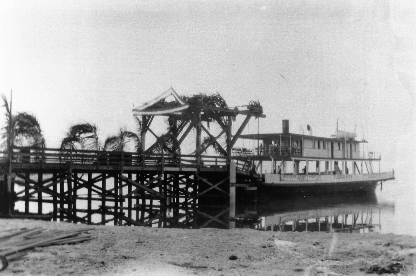 When the Overseas Highway formally opened in 1928, it was still a work in progress. In order to complete the drive from Miami to Key West it was necessary to take a ride aboard an automobile ferry, bridging a 41-mile gap in the highway that separated Lower Matecumbe from No Name Key. During construction of the highway, also known as State Road 4A, roads had been created in the Upper and Lower Keys, but not in the Middle Keys. The building of roads in the Marathon area, as well as two additional ferry landings, began in the early 1930s. Ferry landings built on Grassy Key and on the Gulf side of Hog Key shortened the highway gap from 41 miles to two shorter trips spanning a total of 28 miles. While those driving from Miami to Key West now spent less time riding on an automobile ferry, they spent just as long sitting in lines awaiting the arrival of the next ferry. The ferry landing at Grassy Key would have been similar to the landing pictured in the image. Brad
KEY WEST
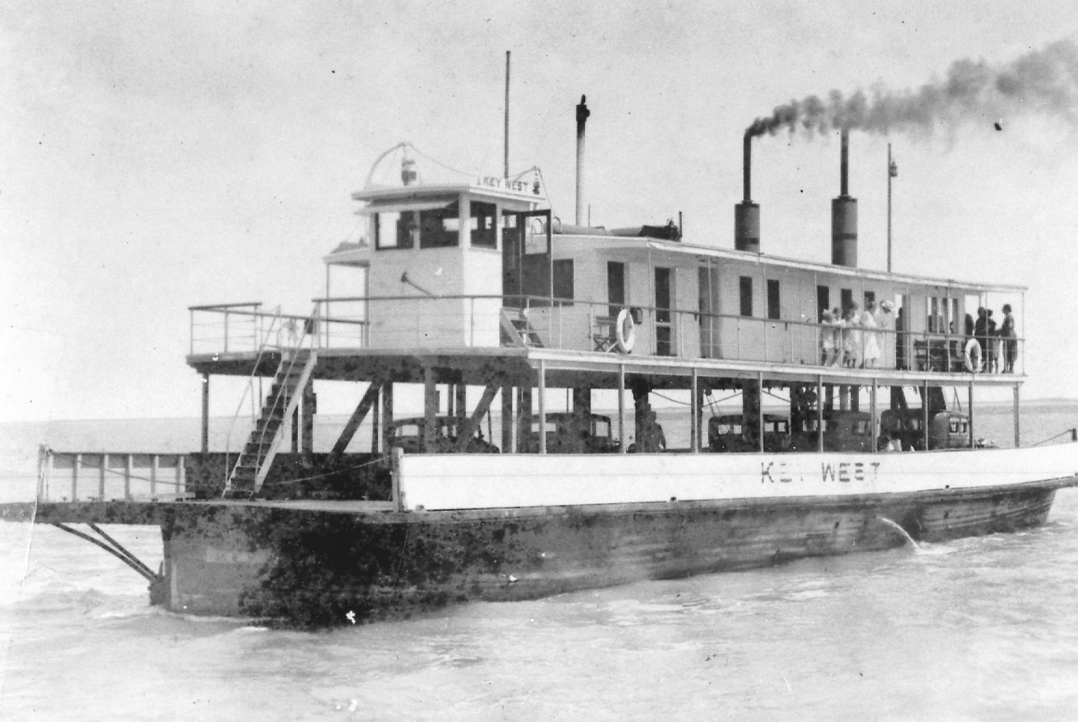 When State Road 4A, more commonly known as the Overseas Highway, opened to public use on January 25, 1928, it became possible to climb into a car in Miami and drive all the way to Key West — more or less. The road was incomplete. To make the entire trip to Key West, it was necessary to include a ride aboard an automobile ferry. The ferry system bridged the 41-mile gap in the highway between Lower Matecumbe and No Name keys. At No Name Key, vehicles would disembark and complete the drive to Key West. To do the job, three automobile ferries had been purchased from Gibb’s Shipyard in Jacksonville for a total cost of $850,000. Each was capable of transporting up to 20 cars at a time. The ferry departed Lower Matecumbe daily at 8 a.m. and 1 p.m. The trip took about four hours, provided the weather and tides cooperated. Vehicles less than 14 feet long were charged $3.50, while those longer than 16 feet cost $6.50. Ticket prices included the driver, but passengers were assessed an additional fee of $1 each. The ferry pictured here is the “Key West.”
Photos: Jerry Wilkinson Collection
— BRAD BERTELLI, Curator Keys History & Discovery Cente


