


The Florida Keys are out of “the cone,” but not entirely out of the woods. County schools will be open on Monday and officials request that all cars parked at Key West High School be removed today.
Tropical Storm Ian is projected to rapidly intensify into a hurricane later today or tonight, but is still tracking “well west” of the Florida Keys, Jon Rizzo, warning coordination meteorologist told county officials on a Sunday morning storm coordination call.
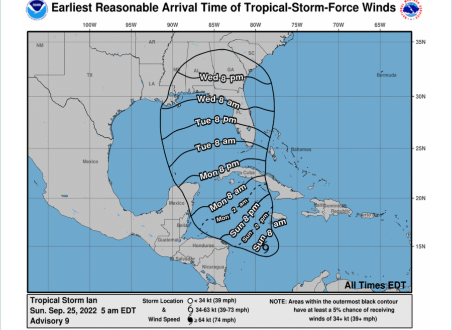
“Tropical storm watches will likely be issued later today for the Lower Keys through the Dry Tortugas,” Rizzo said. “It now looks like tropical storm impacts for the Lower Keys Tuesday afternoon, but possible late Monday night.”
Key West and the Lower Keys have a 45% chance of experiencing sustained tropical storm-force winds, Rizzo said.
“But I do urge caution because even the westernmost storm track forecasts that we could get a few nasty, but quick squalls capable of winds at 70 mph or above,” he added. And with those strong thunderstorms comes a “marginal” risk of tornadoes.
“So we’re also looking at this as a severe thunderstorm/tornado risk,” Rizzo told officials Sunday morning. “Some of these squalls could be vicious enough to produce areas of damage on Tuesday and lingering into Wednesday,” Rizzo said, adding that the marginal tornado risk could start evolving late Monday night.
Rainfall could exceed two to four inches throughout the Keys, with Key West potentially receiving 6 inches of rain.
No evacuations have been issued and no local shelters are being opened as of Sunday, said Shannon Weiner, Monroe County’s director of emergency management.
Airports remain fully operational, said Richard Strickland, director of airports.
Gregory Barroso, the city of Key West’s director of emergency management, told Weiner the city is concerned about its liveaboard boater population, homeless residents at the Keys Overnight Temporary Shelter (KOTS) and other vulnerable populations. Barroso asked that the county authorize the opening of any needed local shelters by Monday to give people time to get there. Local shelters are typically housed in schools and other public buildings built to withstand hurricane winds.
“We need to wait, watch and stay flexible, but so far, so good,” Monroe County Mayor David Rice said on the Sunday morning call.
The next countywide coordination call takes place at 3 p.m. Sunday.


