The modern path of the Overseas Highway was established in 1944 and generally follows a direct line cleared by the Florida East Coast Railway when they laid tracks for the Over-Sea Railroad.
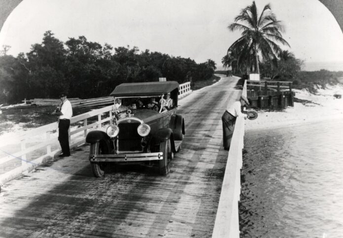
The first incarnation of the highway, officially identified as State Road 4A, was built in the mid-1920s. It was a dusty, rocky road that was sometimes locally referred to as Old Bumpy. For every mile driven down the road, the automobile (and its passengers) bounced a half-mile up and down.
J. Otto Kirchheiner, chairman of the Monroe County Commission, is credited as the first person to traverse State Road 4A, the inaugural Overseas Highway, when he made the trek between the mainland and Key West on July 18, 1927. The celebrated opening of the road to public use was held on Jan. 25, 1928.
In those days, a car leaving Key West and driving to the mainland would have crossed a wooden trestle bridge over Cow Key Channel to reach Stock Island. From there, State Road 4A roughly paralleled the modern Overseas Highway until it passed Chico’s Cantina (and their yummy tamales) and curved right down the roads now called MacDonald Avenue and Maloney Avenue. A wooden trestle bridge once existed where Maloney Avenue approximately ends and connected Stock Island to Boca Chica Key.
At Boca Chica, the scars of the old road can still be seen where it once skirted the island’s edge and the end of the runway at Naval Air Station Key West. Parts of the road are still used, and it is now identified as both Boca Chica Road and 941. The original path followed Boca Chica Road and crossed the bridge over Geiger Creek. It then traveled to what is now Caribbean Drive. It continued past the Geiger Key Marina (and another of my favorite restaurants) to the end of Geiger Road, where a series of wooden trestle bridges were built to cross Bird Key and Saddlebunch Harbor before reaching the Saddlebunch Keys.
The old road crossed the Saddlebunch Keys along the island’s Atlantic edge, crossed over Sugarloaf Creek, and on to Sugarloaf Key. On Sugarloaf Key, parts of the road, now identified as 939, are still used. In 1928, the road hugged the Atlantic coastline and crossed Sugarloaf Boulevard before turning left and running up the island, where it passed Pirates Cove and continued to the current Overseas Highway. There, it crossed (what would have been the railroad tracks) at what is Mangrove Mama’s, where the road continued through the restaurant’s parking lot before turning right and crossing Bow Channel on a wooden trestle bridge.
At Cudjoe Key, the road continued to generally parallel the current highway, passing behind Broil Restaurant and continuing across the island until it reached Kemp Channel, where a wooden trestle bridge connected the road to Summerland Key. The original route traveled about a block away from the modern highway to what is today Center Street, located behind Tonio’s Seafood Shack.
There, a wooden trestle bridge crossed Niles Channel to Ramrod Key. The road continued across the island, behind the Five Brothers Market and Boondock’s to the Torch Ramrod Channel. A bridge connected Middle Torch, and the road skirted the Torch Channel to Little Torch Key.
At Little Torch, the road turned left and traveled down the island to just after what is now Lobster Tail Trail, where it ended at a wooden trestle bridge that crossed Pine Channel to Big Pine Key. At Big Pine Key, Watson Boulevard travels along the route originally called State Road 4A. The path travels past the No Name Pub to Bogie Channel and continues to No Name Key, where the original road terminated.
The first Overseas Highway was incomplete and required automobile ferries to bridge the 40-mile gap between No Name Key and Lower Matecumbe Key. Two ferries operated in 1928, one at the terminal at No Name Key and one at the terminal at Lower Matecumbe Key. They departed twice daily, at 8 a.m. and 1 p.m.
Upon arrival at Lower Matecumbe Key, the road traveled uninterrupted to the mainland. It paralleled the railroad across Lower Matecumbe Key and rambled through the parking lot of what is today Robbie’s Marina and along the bayside of the railroad fills connecting Lower Matecumbe to Upper Matecumbe Key — it was not until 1938 that bridges were added to this span.
On Upper Matecumbe Key, the road continued on the bayside before crossing over the train tracks to the oceanside where the Pines and Palms Resort is now, and traveled down the island, passing behind Midway Café and the Green Turtle Inn. As it is known today, the Old Road can still be used to travel over Upper Matecumbe Key, Windley Key and Plantation Key – with short interruptions at the Whale Harbor Channel and Snake Creek.
On Key Largo, the path of State Road 4A is more clearly defined and is used by everyone driving in the Overseas Highway’s northbound lanes. The modern highway has four lanes: two traveling north and two traveling south. The southbound lanes travel along what was originally the path of Flagler’s train. The northbound lanes use the original path of State Road 4A – at least until MM 106.
At 106, the modern highway turns and crosses Jewfish Creek. The original road traveled up what is today County Road 905. Between North Carysfort Circle and the three-way stop, the original path edged east and traveled closer to the shoreline before turning back and coming to where the three-way stop stands. For those who have stopped there and wondered why the fourth option is barricaded off: It no longer goes anywhere.
From there, the road traveled the same way it does today, but the Card Sound Road route rolled over a wooden trestle Card Sound Bridge to the mainland. Of course, these days, the road goes past Alabama Jack’s and their world-famous conch fritters — always worthy of a stop.


