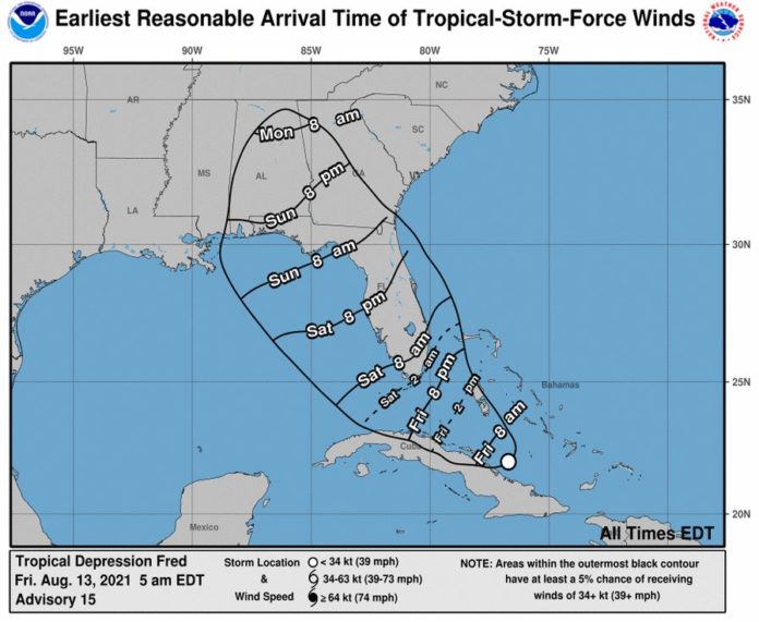
A tropical storm warning is in effect for the Florida Keys. The National Hurricane Center posted the warning on Friday morning as Tropical Depression Fred slowly moves along Cuba.
No forecast changes were made as Fred makes it approach to the Keys on Saturday. Residents can expect periods of heavy rainfall and possible tropical storm-force winds. With possibilities for downed trees and power outages also comes the threat of a tornado.
Jon Rizzo, warning coordination meteorologist for the National Weather Service Key West, told Keys officials during a Friday morning call that Fred is expected to move near or just north of Cuba today. There’s uncertainty, however, over the location of the storm’s center.
“The plane’s been out there looking at it. What was at least the center or feature they were following may have gone inside Cuba,” Rizzo said. “They can’t fly right into it. They don’t have permission this morning.”
Rizzo said weather from Fred is located east and southeast of the center. The storm could be upgraded from a depression to a tropical storm later today.
“It’s one of those systems that doesn’t come with a lot of heavy weather. The system comes first and the weather follows,” he said.
As of 8 a.m. Friday, the tropical depression is traveling at 10 mph, with maximum wind speeds of 35 mph.
The Keys could see a potential for 3 to 5 inches of rain, and some areas could get 8 inches of rain with high tide during predawn hours on Saturday. Tropical storm-force wind threats remain low, Rizzo said.
“Think of conditions to your Elsa and Eta where it wasn’t a big sustained wind event,” Rizzo said.
A declaration of local emergency signed by Mayor Michelle Coldiron will go into effect at noon today. Monroe County Emergency Management is advising residents in campgrounds, recreational vehicles, trailers, liveaboards and trailers to seek shelter with friends or family in a safe structure for the storm’s duration. Residents are also encouraged to secure their boats, homes and yards.


