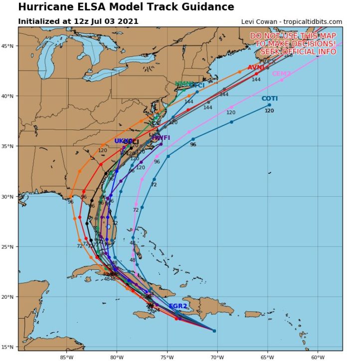
The Keys are expecting a visit by Elsa on Monday evening. The computer models have aligned and there’s a high probability that when it arrives — as a hurricane or tropical storm — it will affect the Middle and Lower Keys.
Hurricane Elsa continues to move quickly through the Eastern Caribbean. While wind speed has dropped back to 75 mph, the size of the storm has increased — 125 miles from side to side. As of now, local officials are not cancelling 4th of July activities, but will revisit the storm track and intensity forecasts again today at 11 a.m. and 5 p.m.
“It looks like our visitors will be able to enjoy the fireworks and then get up early in the morning and leave,” said Monroe County Administrator Roman Gastesi.
It’s likely tropical storm watches will be issued for the Florida Keys later today. As of 5 a.m. this morning, the storm is located southeast of Haiti and the Dominican Republic.
Currently, the track calls for Hurricane Elsa to cross Cuba almost on a diagonal, affecting western and central Cuba on Monday, July 5. That much interaction with land is expected to weaken the storm, and slow its forward speed to 15 mph. Officials say it is still too early to forecast whether it will be a tropical storm or hurricane when it reaches the Florida Keys.
Currently, Hurricane Elsa’s forward speed is almost 30 mph, a record-breaking speed according to National Weather Service’s Jon Rizzo, warning coordination meteorologist. Although the National Hurricane Center has “sped up” the storm, with the earliest possible arrival of tropical storm force winds in the Keys to Sunday, July 4 evening, Rizzo emphasized that is the very earliest. He said it’s more likely that the winds will arrive on Monday, July 5 somewhere between noon and 2 p.m.
The forecast track has been stable and little deviation is expected. There is almost no chance that the storm will pass to the east of the Florida Keys and most tracks carry it across the Middle to Lower Keys or west of Key West.
NOAA officials are calling for 2 to 4 inches of rainfall over the Florida Keys, with a possibility of localized amounts of 6 inches and possible isolated tornadoes. Surge predictions continue to be about 2 feet above normal on the oceanside of the Florida Keys.
Florida Keys residents should prepare for fast-moving squalls beginning Monday afternoon and to take protective measures like bringing items inside that could be blown around by the wind. Operators of high-profile vehicles (trailered boats or RVs) are encouraged to make decisions today whether they will leave before Monday morning (July 5) or wait until the storm has passed on Tuesday, July 6.


