By Jim McCarthy & Alex Rickert
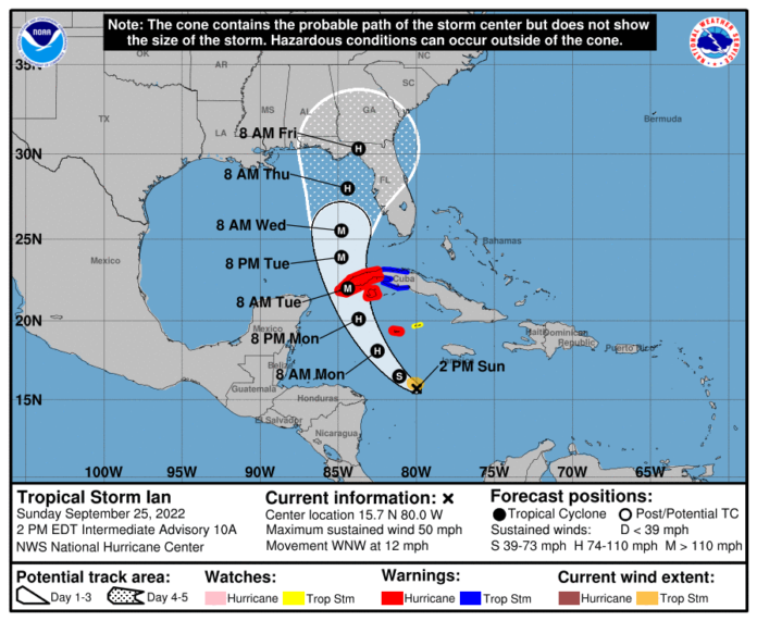
As Tropical Storm Ian begins to organize and strengthen, a Tropical Storm Watch is expected to go into effect later today for the Lower Keys from the western end of 7-Mile Bridge through Key West. It will likely upgrade to a Tropical Storm Warning by tomorrow morning.
Jon Rizzo, warning coordination meteorologist with the National Weather Service, told local officials on Sunday afternoon that the tropical storm is expected to be a “large-sized hurricane peaking at near Category 4 strength over the next 60-72 hours.” While current models still show the storm passing well west of Key West, Rizzo said residents in the Lower Keys could begin to see rain and winds early Tuesday morning.
“We’re already focusing on the Lower Keys as an area of getting the strongest impacts with sustained tropical storm force winds,” he said. “Unless there are any eastward shifts in the forecast, this is more of a tropical storm type of event.”
Though the likelihood of sustained tropical storm force or destructive winds continues to drop throughout the Keys, Rizzo said squalls with gusts of 50-70 mph “would not be surprising.” On a scale of 1-5, chances of isolated tornadoes resulting from squalls in the Lower Keys is a 1.
Rainfall estimates remain around 2-4 inches throughout the Keys. In Key West, the rainfall total could be around 6 inches. Further guidance from the National Hurricane Center on flood impacts is expected after Sunday’s 5 p.m. advisory. However, Rizzo said the early expectation is that tides are expected to be about a foot above king tide highs as winds from the south cause ocean overwash with the storm’s approach late Tuesday and early Wednesday.
The water could “actually pile up at its most” on the gulf side after the storm passes and weather begins to improve. Once the storm passes, he said the water could “actually pile up at its most” on the north side of the Lower Keys and Key West, with more precise estimates available after the evening advisory.
County emergency management officials haven’t issued any evacuations as of Sunday. And no shelters are open yet.
Discussions over opening shelters and any school closures on Tuesday will be discussed on Monday. Clerk of the Court Kevin Madok said his offices will be open to the public on Monday.


