On Sept. 30, staff from the Florida Keys National Wildlife Marine Sanctuary presented region-specific details of its Restoration Blueprint in the Marathon High School auditorium. The plan outlines the details of the management plan itself, changes to the boundary of the sanctuary, sanctuary-wide regulations and changes to marine zones and zone regulations. The sanctuary has said there are four alternatives for every spot and the first is the status quo option, or “no change.” However, in many instances the blueprint only offers two alternatives. Below are five zones in the Middle Keys that may see changes in the way they can be accessed, used, or made off limits — however, they are NOT the only proposed changes to Middle Keys waters.
• Sombrero Key SPA
• Delta Shoal SPA
• Marathon SPA (not pictured)
• Coffins Patch SPA (not pictured)
• Turtle Shoal SPA (not pictured)
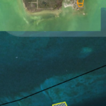
This area is located Oceanside near Sombrero Lighthouse and due south of Boot Key. Delta Shoal is located just to the east, and the Marathon and Coffins Patch are also oceanside to the east of Duck Key.
Sombrero Key is currently a Sanctuary Preservation Area that is 0.3 square miles. Alternative 2 keeps it the same size, but makes it idle speed and no anchoring zone. Alternative 3 make is idle speed, no anchor, and open to commercial businesses that are Blue Star certified (non-commercial users would also have access, the sanctuary has said). Alternative 4 is identical to alternative 3 but the area size is increased to 0.5 square miles.
The agency’s purpose is to protect the reef and limit use.
The Delta Shoal and Marathon Shoal are currently unregulated. Alternatives 2, 3 and 4 are identical and would make it into a Sanctuary Preservation Area that is idle speed with no anchoring and no fishing.
Coffins Patch is currently a 0.4 square mile area that is a Sanctuary Preservation Area. Alternative 2, 3 and 4 are identical. Those make the SPA also idle speed and no anchor zones in addition to no fishing. Turtle Shoal is currently unregulated. Alternative 2 proposes an SPA area with idle speed, no anchor and no fishing. There is no Alternative 3. Alternative 4 makes it transit only, which means no stopping for fishing, diving or snorkeling.
Delta Shoal is proposed for an area of 0.13 square miles.
Marathon Shoal is approximately 0.11 square miles.
Coffins Patch SPA is approximately 0.39 square miles.
Turtle Shoal SPA is approximately 1.41 square miles.
The sanctuary’s aim is to protect coral.
• Long Key
• Tennessee Reef
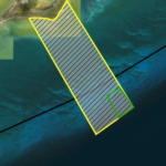
This are is located Oceanside off Long Key. It is 9.57 square miles.
There are four alternatives for Tennessee Reef Special Use Area/Conservation Area. Currently, there is a transit only area that measures 0.2 square miles. Alternative 2 keeps it as a transit area that is slightly larger, 0.7 square miles. Alternative 3, the agency’s preferred option, makes it a Sanctuary Preservation Area that allows only idle speed through the zone, with a corner notched out for transit only, meaning no fishing, diving or snorkeling. Alternative 4 makes the entire 9.6 square miles transit only.
The agency’s purpose is to protect a large continuous swath of habitat and it is a possible site for coral restoration.
• Gulfside Banks
• Channel Key Banks
• Old Sweat Bank
• Jewfish Bush Banks (not pictured)
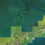
This area is located north of the Overseas Highway in between Duck Key, Conch Key and Long Key.
The largest block with a green border is the proposed Channel Key Banks Conservation Area; it would also be “transit only,” meaning no anchoring, fishing or diving. The sanctuary’s aim is to protect a large, contiguous shallow habitat and decrease prop scarring.
There are only two alternatives proposed for this Wildlife Management Area. The first is status quo (no change). Alternatives 2, 3, and 4 are identical. The agency’s preferred solution is to make all of these areas idle speed. The sanctuary’s aim is to protect seagrass and hard-bottom habitat.
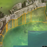
• Moser Channel Banks
• Red Bay Banks
• Bethel Bank
• John Sawyer Bank
• Rachel Bank (not pictured)
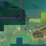
This area is located just north and west of Marathon.
There are only two alternatives proposed for this Wildlife Management Area. The first is status quo (no change). Alternatives 2, 3, and 4 are identical. The agency’s preferred solution is to make all of these areas idle speed. The sanctuary’s aim is to protect seagrass and hard-bottom habitat.
The largest block with a green border is the proposed Red Banks Conservation Area; it would also be “transit only,” meaning no anchoring, fishing or diving.
The sanctuary’s aim is to protect a large, contiguous shallow habitat and decrease prop scarring.
This area runs from the edge of Tingler Island in the west to Vaca Cut at the east.
There are only two alternatives proposed for this Wildlife Management Area. The first is status quo (no change). Alternatives 2, 3, and 4 are identical. The proposal is to not allow motor vessel traffic. There are 10 channels that bisect the area leading to deeper ocean waters. The sanctuary’s aim is to decrease disturbance to nearshore grass and hard-bottom habitats and decrease prop scarring.
Subscribe To Our Newsletter
Get Keys Weekly delivered right to your inbox along with a daily dose of Keys News.
Success! Please check your email for confirmation.


